Daily Archives: June 9, 2011
Fish and Firetrucks . . .
Today was a road trip day so no coffee at home since we were going to eat breakfast again at the Hi-Lo Diner before hitting the road.
This time I tried something different and it was really good. A Pork Carnitas Burrito.
Made with Scrambled Eggs, Shredded Pork, Green Chiles, and Onions inside a burrito, it was very tasty. And the Country Fries and Homemade Salsa just topped it off.
Jan had a Strawberry Waffle with a side of Bacon. Apparently it was so good she didn’t even let me get a picture before she dove in.
After a great meal, we headed out to drive the Old Stage Rd down to the town of Mt. Shasta. Our destination was the Sisson Museum and the adjacent Mt. Shasta Fish Hatchery.
The Sisson Museum, named after Mt. Shasta City’s name until 1924, opened in 1983 and gives you a great overview of the Mt. Shasta area.
One thing I found interesting were some of the old photos taken at the top of Mt. Shasta. I wondered about the purpose of this pylon at the summit.
Checking another exhibit gave me the answer. It was a Geodetic Survey marker. Installed on the top of Mt. Shasta in 1875 to aid in drawing survey lines in the newly-opened West.
The highly-polished shape of the ‘conoidal’ cone on top reflected the sunlight in all directions making it a brightly-lit beacon on the mountain top, visible for more than 200 miles away.
Falling into disuse after the surveys were completed, it stood until sometime between August and October 1903, when it was apparently struck by lightning and blown off the mountain top, landing several thousand feet below.
It was not seen again until 1912, and the top was not recovered until 1949, when three men brought it down. It was stored until it was donated to the museum in 1984.
Another thing I found interesting is that on the display telling many of the highlights of the mountain, the number of fatalities is changeable.
Sounds like a good enough reason to just admire the mountain from afar.
This is a 1915 Ford Fire Truck, one of only 6 made, and the only one to survive.
It contained a 20 gallon tank of a water/baking soda solution, so to activate it, a ladle of concentrated sulfuric was dumped into the tank and stirred. When the lid was clamped down it developed as much as 150 psi, spraying the solution on the fire. Of course the tanks sometimes blew up from too much pressure, so maybe that’s why they only made six.
Leaving the museum, we walked next door to the Mt. Shasta Fish Hatchery. Built in 1906, it is the oldest hatchery still operating west of the Mississippi. At first it handled salmon, then salmon and trout. Now it supplies four different species of trout, including Rainbow and Brown Trout.
The first thing you see are the outside growing ponds, fed by the icy cold waters of a nearby creek. Note the netting overhead to keep out hungry hawks.
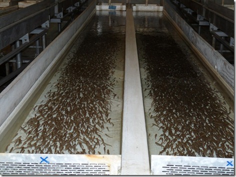
But everything starts here in the Incubator Building where the spawn are hatched and fed.
There are as many as 20,000 minnows in each of these tanks, and there are several dozen tanks.
When they’re large enough they’re moved outside through a progression of ponds as they grown in size. At this size, as fingerlings, they may be airdropped into rivers and streams.
These look almost ‘eating size’ and will be deposited into rivers from large truck tanks.
We also saw three hawks regularly floating overhead, so that explains the netting.
Leaving the museum and hatchery, we drove back into Mt. Shasta City and got another great view of the mountain.
Getting back on I-5 we headed south about 60 miles to Redding. We wanted to see the area and also stop off at a Tractor Supply Store.
We had also seen signs for the Sundial Bridge near the Turtle Bay Museum, and wanted to check it out also.
It turned out to be a pedestrian / bicycle bridge crossing the Sacramento River that also functions as a giant sundial. Built in 2004 it is a cantilever spar cable-stayed bridge (you really wanted to know that, didn’t you.) that stands 266 feet high and is 700 feet long.
These photos from the Internet gives another view.
The bridge deck is made of structural glass and is illuminated at night for a spectacular effect.
Leaving the bridge we drove around Redding for a while before deciding to have a late lunch at a nearby Marie Callender’s.
On the way I saw gas for $3.82 so I decided to fill up, as it’s $3.99 back in Weed.
After a good meal, and pie to go, we headed back to the RV, taking in more great views along the way.
This is Mt. Shasta, seen from Redding. According to the map it’s 58 miles away.
What stuck both Jan and I is how visible Mt. Shasta is from so far away, and yet it was so overcast last Saturday when we drove here in the RV that we never saw the mountain until we were in Weed, and even then it was covered in clouds.
Another shot from about 15 miles away.
Getting back to Weed, we stopped in at the Pilot right next door to the RV park so I could get a cappuccino. Without Nick Russell around, I’d been in withdrawal.
——————————————————————————————————————-
Thought for the Day:
“The purpose of fighting is to win. There is no possible victory in defense.” — John Steinbeck
adsfd


